Boonesborough to Valley View
By Wesley Houp
“Curiosity is natural to the soul of man, and interesting objects have a powerful influence on our affections.”
—Daniel Boone
On a sunny, 35-degree afternoon in March, we haul our boats down I-75, cross the river at Clay’s Ferry, hang a left on U.S. 627, and make our winding descent to Boonesborough and lock 10. Our objective: reconnoiter the watershed below Boone’s famous fort, make note of all curiosities, and emerge from the river valley approximately 20 miles downstream at Valley View in two days’ time. It’s my inaugural voyage with this particular coterie of slackwater venturists, and I find myself in the odd rank of newbie and Kentucky River native (river expert by association) simultaneously.
Honestly, I’ve known everyone in the group for at least a decade, and have paddled the river with at least two of them (Troy and Lyle) on numerous occasions in what now seem ancient incarnations. In July of ’95, Troy and I undertook a week-long river-womp from Beattyville to High Bridge, and we, along with Lyle, paddled the lock 7 pool and Dix River tailwaters so often that our wakes seemed permanent. But that was then—the salad days of my tenure living on the river, ’93 to ’98. We were young, boundless, and the river was ours to discover, conquer, and score with our brands. Today, however, we’re middle-aged, a bit less boundless; the river is ours to rediscover, but we’re more content to float, pass through, leave the world as we find it. Add to the mix, Danny, paddlemaster responsible for this prop-less assemblage, and Gary, even-keeled, soft-spoken—the only one of us who seems capable of acting-his-age-with-any-regularity-but-not-really—and the flotilla is complete.
Once off the ramp, riverwind trumps any warmth the noonday sun might provide, gathering up cold in the shadowy bend near the Kentucky Stone Company quarry and delivering it headfirst so that the blood circulating inside our faces congeals in our cheeks. Past this bend and Memorial Bridge, though, we hit a half-mile of tranquil air and water flanking Boonesborough Camping Ground and Marina, where a flock of resident Canada geese enjoy what appears to be semi-permanent refuge, lured in, no doubt, by the convenience of ever-treating and semi-permanent campers. Curiously, both species seem to have lost their bearings—not to mention all sense of real adventure and nominal position in the gristmill of life.
The array of RVs on the Clark County bank seems anathema to Boone’s reenacted fort just up river on the Madison County side. Boone forged Wilderness Road in 1775 through dense woodland, endless canebrake and rolling savannah with guns, axes and ploughs and opened the west. RVer’s return to the spot, 2011, via U.S. 627, to reclaim some wildness all but lost to many Americans, to “rough it”—or at least stare out at the river and cliffs through mildewed camper windows and swirling carboniferous haze of Kingsford briquets.
Another mile downstream the river bends sharply southwest and begins a 37-mile course-change through a girdle of Ordovician palisades. At the southern-most tip of what is now Jessamine County, it recovers a northwesterly meander to the Ohio. Near the beginning and end of this redirection, the river intersects the shallow but prominent Kentucky River Fault Zone, plainly visible at Clay’s Ferry and farther down at Camp Nelson. The “Jessamine Dome” forms the highest point along the geological formation known as the Cincinnati Arch, a Pliocene upheaval stretching from Northern Kentucky to south of Nashville, Tennessee, and through this stretch of sheer cliffs, the river crisscrosses the fault-lines no less than nine times—a bird’s nest of subterranean, hairline fractures sutured by a listless, ancient thread of water.
Shipwrecked on Lisletown ledge
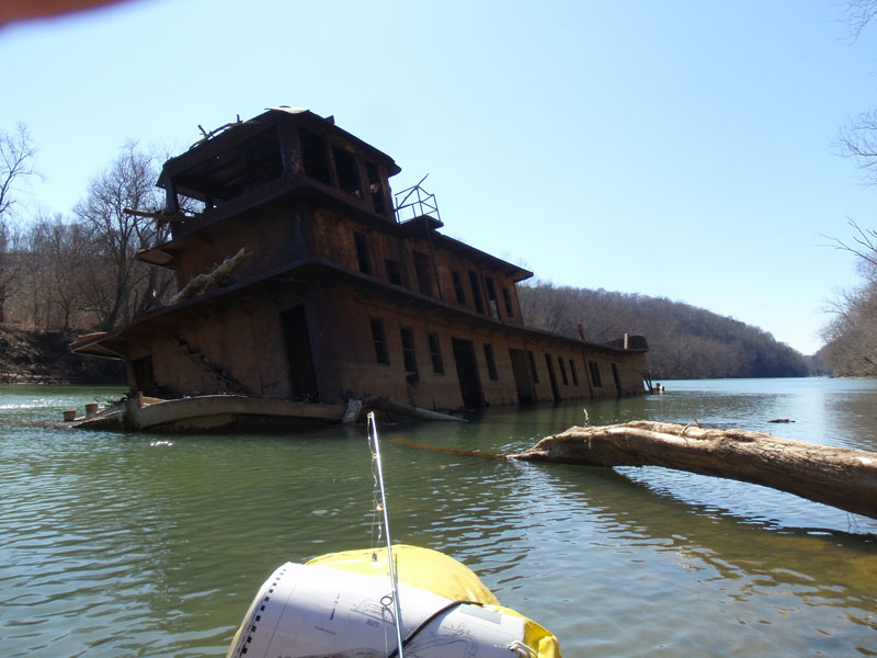
Just around the bend, Lower Howard Creek enters the mainstem on the Clark County side near the hamlet of Lisletown. Troy pulls ahead as the bend opens to a long straightaway and soon angles alongside a half-sunken tow–the Brooklyn. The old steel-hulled, sternwheel diesel came into this life in 1929 under the name Helen H. and worked the upper-Ohio watershed. In the mid-40s, Captain John Donaldson bought and refurbished the tow and put her to work hauling sand down the Kentucky. He renamed her Brooklyn after the site where he often docked below lock 7. But her tenure on the Kentucky was cut short by size and heft; she was too slow to remain a solvent business venture and compete with smaller tows (let alone rail transportation) on the narrow, meandering Kentucky. So he eventually stripped the Brooklyn down to decking and hull and docked her below Boonesborough for good.
“You know,” I conjecture, “the problem with the Brooklyn is that she was built like a giant fucking anchor. Even in this dilapidated state she’s behemoth. What was it that Thoreau said? ‘If rightly made, a boat would be a sort of amphibious animal, a creature of two elements, related by one half its structure to some swift and shapely fish, and by the other to some strong-winged and graceful bird.’ I realize he didn’t have diesel tows in mind, but still… This boat is half humpback and half B-52.”
The old ghost was sold in the 80s, and the new owners towed her to her current location, below the mouth of Lower Howard, in fleeting hopes she might live again as a floating restaurant or some other profitable curio. During the drought in the late 80s, however, the river-level dropped so low the Brooklyn lodged permanently on a sharp ledge, the limestone piercing her aged hull and relegating her once and for all to shipwreck status—not the kind of tourist curiosity the new owners had in mind. But a marvelous curiosity she remains.
As Troy paddles around all sides, gaining just the right angles with his camera, I paddle into her lower deck. It’s clear the hull has been wrenched open; sunlight refracts up through the water column on her starboard, channel-facing side. Two stories overhead, the pilothouse stares blindly upriver, a colossal, rusted eye-socket. The rest of the crew paddle through a bulkhead door into the lower deck. We float on an illuminated emerald cloud, the water infused with particularly radioactive-green algae that flourishes in cold temperatures. Danny produces deli sandwiches and begins piecing them out, while Gary brandishes a handle of Laphroaig ten-year old. Scotch and Genoa salami offer heat to recharge the body; the shadowy, forlorn hull of the Brooklyn counters with bone-chilling cold to refocus the spirit. After a brief inspection of the engine room, we push off. Little over three miles separate us from our bivouac on Boone Creek. Charged by the holy meritage of liquor and lore, though, we make the mouth in a smooth, cold river-hour.
Camp on Boone Creek
Steady traffic on Clay’s Ferry Bridge whines high above us, filling the valley, and from where we idle in the mouth of Boone Creek, the passing trucks and cars sound like a swarm of Jurassic hornets busy at some ominous and strangely stationary task. But long before interstates and highways spoiled this stretch of riverscape, Daniel Boone, then 45, crossed the river and led his and several other families down the Clark County bank, escaping fortress Boonesborough—andthe incessant claim disputations of land-grabbing commissioners from Virginia. It was Christmas Day, 1779. They trudged through ice and snow, their destination what would come to be known as Boone’s Station near the confluence of Boone Creek and Baughman Fork.
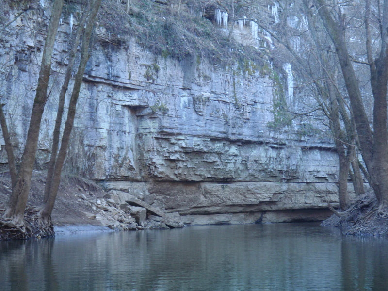
The creek marks the boundary between Fayette and Clark counties, and soon inside the narrow mouth, palisades rise on the Fayette bank. Barely a quarter mile in, shallow water prohibits any further progress; but the shoal is broad and flat enough to hold our beached crafts. We pitch tents on fine pebble, coated with a layer of frozen river silt. Surrounded to the north by open wood—primarily sugar maple—the rock-face to our south reflects the deepening shadows’ cold back to us, so we busy ourselves with fire.
It’s already past five o’clock, the sun long gone beyond the Fayette palisade, and frost is forming on the shadowy lengths of fallen timber. Behind us on the creek-bank, a flock of wild turkeys disrupts the gathering stillness with cackles suggesting time to haul tail and roost. When our fire finally matures, stars are twinkling through the bare canopy. For dinner, it’s chicken livers, pork chops and rye bread. We linger around the fire deep into the night, passing the Laphroaig, watching our own shadows play upon the nearest trees, and imagining a time, not all that long ago, when such exposure in the wilderness was murderously stupid.
Sugar-making
We awake to a crystalline dreamscape. Lyle’s first up and kicking unburned log-ends back into the ember-core when the rest of us emerge. “Got down to 19 degrees, but we should have sunlight within a few hours,” he says, pausing to rub smoke from his eye. High above on the canopied cliffs, yellow light floods the bare maples, but creek-side everything is dim with thick frost, including our tents and gear.
“I wonder how many times Boone froze his johnson near this very spot? Thank god for fiber-filled sleeping bags,” Troy interjects with a disgusted look at the thick rime covering his tent.
“Give me deerskin and buffalo hide any day,” Danny replies. “You know, they were naturally water-repellent. I mean, when’s the last time you saw a cold, wet buffalo?”
Troy unpacks a dozen eggs from the food bag, and Gary proffers up a thick slab of bacon. Within minutes, breakfast is crackling in the pan. Danny turns to warm his frozen posterior. Relaxing against the fire, he intones:
“Ah, for some maple syrup. You know boys, when Boone moved here in ’79 it was the coldest winter on record. The settlers in Kentucky referred to it ever after as ‘The Hard Winter.’ So cold, they say, a man’s rifle wouldn’t fire, and on the off chance it did, then it wouldn’t fire again. Wild turkeys froze to the ground and suffocated when their nostrils clogged with ice. But in February of 1780, despite heavy snow and bitter cold, Rebecca Boone ventured out with the other women and children at Boone’s Station and collected sap in the maple groves nearby, not unlike the maple grove flanking our shoal, boiling and refining the sap to syrup and finally to sugar. Unable to forage in the frozen woods, buffalo wandered in close to lick the sap buckets and couldn’t be shooed away.
“Apparently Boone himself was a master sugar-maker. Seems only right, given his skill at making salt, too. He was no farmer, they say, but a true hunter-gatherer. His heart was in the woods, and he preferred to toil there, be it stalking game, surveying creek bottoms, or collecting and reducing maple sap. It was an activity that Daniel and Rebecca enjoyed together in all their wild cohabitations. In 1797, even while Boone was being sued by every Johnny-come-lately over this or that ‘fraudulent’ survey, the couple boiled over 500 pounds of maple sugar. Five-hundred fucking pounds. It takes forty gallons of sap to make one gallon of syrup. And for ten gallons of syrup, you might realize eight pounds of maple sugar. To get 500 pounds of sugar, they had to collect 25,000 gallons of sap. Now that’s epic foraging, brothers. Before Europeans arrived, Indians used maple sugar to sweeten an otherwise humble existence. It could also be fermented into mean-ass mead and even distilled into crude white lightning—just the ticket for inducing bottle fever on sub-zero frontier nights.”
Danny pauses for a long pull of Laphroaig. “Plus, psychically, sugaring signaled a renewal of life, the promise of another spring for beleaguered souls beyond the margin of civilization.” And with that, he turns again, raising his palms in obeisance to the fire spirit.
The rising aroma of bacon, coupled with heady thoughts of maple syrup, triggers spontaneous formation of a silent chow-procession. The clink of fork and knife subsides just as the sun creeps across our shoal-camp. Within a half hour, our boats are packed; Gary pours coffee dregs across the remaining coals and banks the outer ashes.
Bull Hell to Bill Lail
Back at the mouth, Clay’s Ferry Bar stretches across the Madison County shore, and immediately downstream, the I-75 bridge spans the chasm, its massive supports extending down from concrete undergirds to the Kentucky’s placid surface. Dwarfed in its shadow, the old U.S. 25 Bridge provides a bit more aesthetic stimulation; its iron girders, riveted beams and arching framework remind the languid paddler of a more artful progressive era. Iron bridges like this one were designed to maximize the traveler’s experience of “crossing over.” For the fast, vast majority of present-day motorists, Clay’s Ferry Bridge neuters any and all aesthetic experience of river-crossing: the river is just an afterthought. The sudden, hollow baritone shift of tires spinning off terra firma and on to prefab concrete spans hints to unwary travelers that something monumental has opened up below, but exactly what it is remains all but hidden from view and therefore out of mind. Traffic flows at an unabated breakneck pace. But those few drivers who wind down the bluffs on U.S. 25 see firsthand the ancient river yawning away to the north and angling immediately out of sight to the south. The old route demands patience, and in the time it takes to cross the aged iron structure, Bull Hell Cliff blots out the southern sky, reinforcing one’s insignificance in the steady grind of geologic time.
As our flotilla passes under the array of bridges and sidles up to the fault-line near the base of the cliff, I produce my weathered copy of T. Dionysius Clark’s The Kentucky. “Gentleman, according to Clark, this promontory was named by the legendary, quick-tempered abolitionist and hair-triggered dualist, Cassius Clay, who, among other noble endeavors, raised prize-winning bulls just south of here at White Hall. The story goes he had a pure-bred but infernally stubborn bull, wouldn’t mind and wouldn’t corral. Unable to catch the willful beast, Clay, beset with unrighteous anger, drove it over this very cliff where it fell two hundred feet and slammed down…right about…there…” I point to a ledge near the water’s edge in dramatic guesstimation. “Thereafter, when envious neighbors inquired about his pedigreed ruminant, Clay sneered that he’d gone to ‘Bull’s hell on the Kentucky River.’”
At Bull Hell Cliff, the river bends sharply northwest for three miles, passing Elk Lick Run, Lexington’s municipal straws, and another high palisade. Just beyond these cliffs, the current turns south again, and Raven Run enters the flow from Fayette County. Bill Lail Island, the only permanent (and official) landmass within the Kentucky’s 255-mile mainstem, forms an oblong break in the current and constricts the channel to the east against Raven Bar. We beach at the head of the island; Danny and Gary linger by the boats, looking back upriver toward Raven Run, while Troy, Lyle and I comb the scraggily trees, stumps, and deadfall for flotsam curiosities. Finding nothing, we return and enjoy a rousing round of rock-skipping.
After paddling and shoal-rummaging, rock-skipping is as natural as breathing. It goes something like this: 1) beach your craft, 2) dismount, 3) consolidate the clutter of beer cans and orange peels, 4) bail bilge-water, 5) stretch, 6) scratch, 7) take a whiz, 8) notice flat, round stones, 9) start skipping them. It spreads like wildfire, and commands bachelor-flock mentality. We soon discover that Troy is top-gun. In all likelihood, he could skip a wet cat. Amid our juvenile pronging, Gary pipes in. “Check out the gaping maw on the cliff.” We follow his line of sight, and there, high above us on the far side, Devil’s Meat House bleeds shadow like a puncture wound to the dark heart of the earth.

Savannah
I have a picture of it when it first sunk