
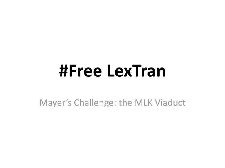
On Tuesday September 17, NoC editor Danny Mayer unveiled design plans for an urban commons across from LexTran. Organized under the theme #FreeLexTran, the plans represented an amalgam of ideas generated through the Mayor’s Challenge, a Lexington-based urban design challenge announced in March. Mayer was granted 5 minutes of time by his District 1 council member Chris Ford to show-and-tell the idea to city council and mayor. The following are the text and images of his power point presentation, lightly revised.
Chris, thank you for allowing me the time to speak in front of council today, and I apologize in advance for the 45 seconds over-time this talk will take.
Council, Mayor, I am Danny Mayer, a thirteen-year resident of the northside who has resided for the past six years in the First District Chris currently represents. I am also a faculty member at Bluegrass Community and Technical College, an urban walker, a slackwater paddler, LexTran user, and publisher of free monthly print community newspaper North of Center.
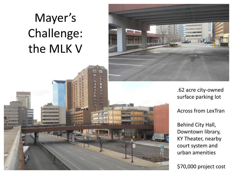
In March of this year, acting as editor of that paper, I issued a “Mayer’s Challenge” design competition for a portion of a roughly half-acre city-owned surface parking lot that sits across Vine Street from the downtown LexTran station and behind City Hall, the downtown library, the Kentucky Theater, and the license/registration buildings. The surface lot also sits nearby a newly renovated parking deck.
The competition called specifically for local class design plans for transforming this important multi-modal urban space. It also asked for local Fayette Urban Countians to make their dreams and plans conform to a budget of $70,000—or approximately $299, 930,000.00 less than the current cost of freeing Rupp Arena. (I say approximately because, after two years of private and public funding, city Rupp leaders have yet to offer either a design or cost for that project.)
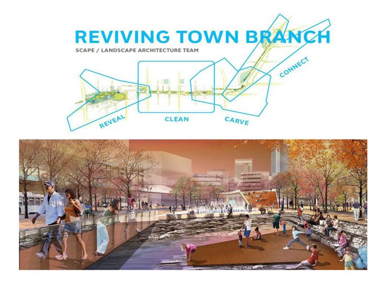
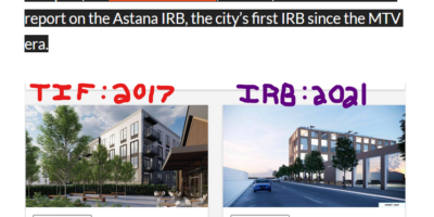
The idea for the challenge grew from the city’s new interest in reclaiming under-used urban space and also from the city’s strong push to create a “commons” for the people of this county. The chosen site for the Mayer’s Challenge, in fact, takes as its design site the cartographic overlay of the Clean and Carve development blocks found in SCAPE landscape architect Kate Orff’s enthusiastically-received “Reviving Town Branch Plan” (which, like Rupp, also offered no funding plan or cost analysis).
The Mayer’s Challenge did stipulate a significant alteration of the Orff design. The SCAPE/Orff plan calls for the MLK viaduct/bridge to be demolished, and for a new “pedestrian bridge” to be built nearby, which you can see in their artist’s rendering here. In the Mayer’s Challenge, however, the MLK viaduct had to stay and be incorporated as part of any design plan. Unlike the Manhattan-based Orff design, our Mayer’s perspective on keeping the bridge was local: (1) tearing down and rebuilding a bridge is terribly expensive; (2) the MLK viaduct is an important northside connector to the University of Kentucky, where MLK eventually dead-ends. Closing the viaduct will force north/south bikers (and cars) travelling to and from UK onto heavier trafficked, narrower, and more dangerous Rose and Limestone Streets.
A third intent of the challenge, my own, was to create a design to showcase and leverage LexTran, our under-appreciated public transportation system.
Below is what we came up with:
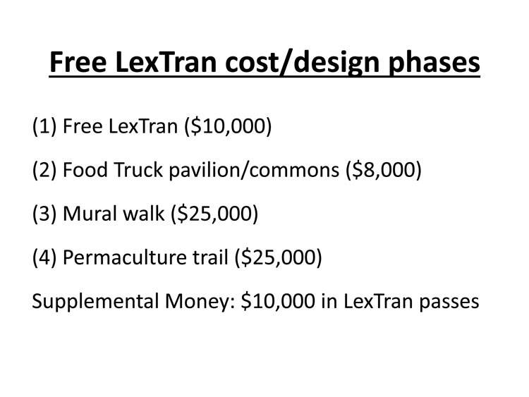
As you can see, the Mayer’s Challenge winning design is organized around four design space-phases, with an additional $9,000 in supplemental money for providing free LexTran city passes to stimulate urban worker ridership and/or to stimulate county-neighborhood-leader-resident ridership.
[Spoiler alert: our initial $70,000 budget has risen 10 percent, to $77,000. We have decided to peg our budget to that of Rupp Arena, whose initial $5 million in city and state start-up funding has reportedly increased to $5.5 million.]
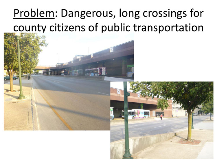
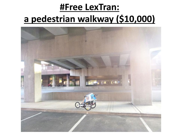
Phase One: Free LexTran
The most important, cheapest, and possibly easiest thing the plan calls for is to free LexTran. Currently, those getting on or off the bus at our downtown station—people like me who lovingly lug a 2 year-old a half-mile there—have our exits and entrances to Main Street woefully aborted. To cross heavily trafficked and fast-moving Vine, I must either cross at Limestone or at a street (I forget its name) located just before Rose. (The man crossing the street in the picture on the lower-right may be what the city’s bike and ped committee had in mind this past summer when they observed that the MLK viaduct needed city attention.) With all the money and interest you claim to want to direct downtown, it’s a wonder you city leaders have not taken a look at LexTran yet!
Phase One of this Mayer’s plan calls for cutting a five-foot opening in the concrete barricades, painting a cross-walk, and allowing pedestrians to cross Vine there—under the “natural” shelter provided by the viaduct. I’ve asked a couple engineers, who claim it to be a simple $5,000 job. I’ve doubled that amount, just in case.
Though it is not budgeted in this plan, if you city leaders were really interested in my safety (and the safety of other bus-riders like me), you would work to put a pedestrian stop light to slow traffic at this point of Vine. Let us FREE LEXTRAN.
Phase Two: Food truck pavilion
And where will these LexTran users travel with their newfound freedom? Across Vine Street to a Food Truck pavilion, of course—located away from residential neighborhoods and out of view from brick-and-mortar restaurants, just like city leaders want. The area beneath the MLK viaduct is also nearby large buildings filled with workers and across from a station that sees 35,000 people board and alight weekly—just like the food operators want.
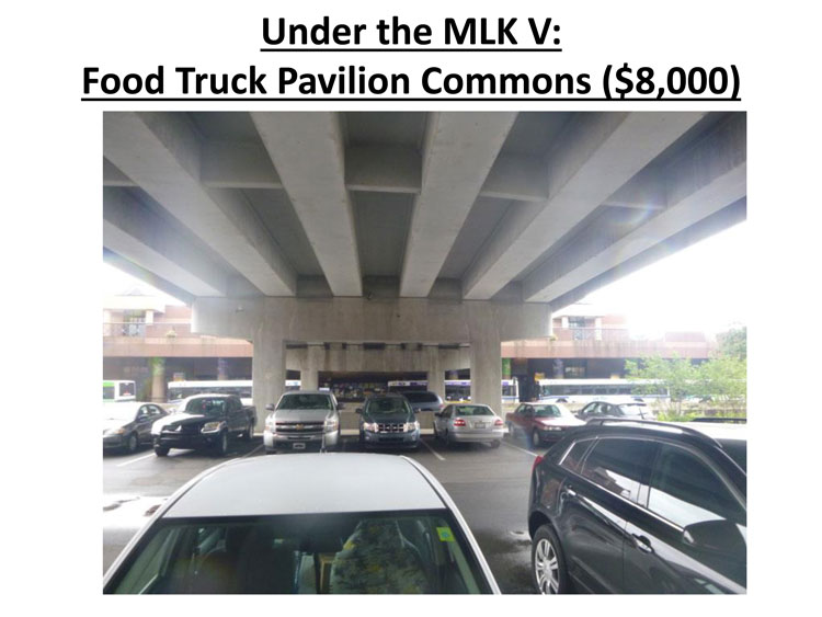
When I contacted him, Sean Tibbetts of the Food Truck Association said he’d definitely be interested.
The $8,000 budgeted for this Phase Two project would go to provide basic seating and event money for public gatherings held on site in warmer weather. Most likely music, but other things, too.
Phase Three: mural walk
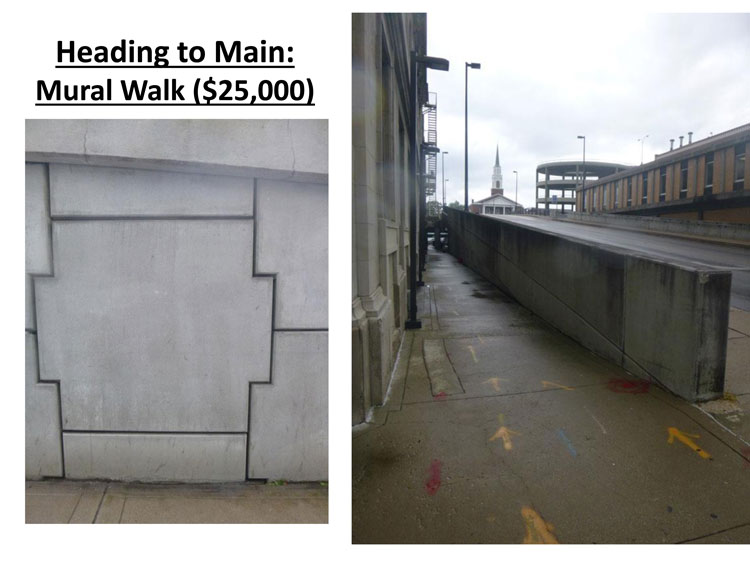
Leaving the food truck pavilion, Phase Three of the design calls for the muraling of the small path that runs alongside the viaduct. Our budget would use the money to pay 8-10 artists to redo this walkway area and the food truck pavilion. Some will collaborate on a regionally-focused mural that details the area’s history in 4-5 separate (individual artist) panels. (Trite bourbon, horse, and UK basketball themes will be strictly prohibited in this Mayer’s Challenge, as they are already amply covered in costly city branding initiatives.) Non-thematic panels, of the size and type viewed in the picture on your left, will also appear lower on the path’s walls.
I have secured work agreements from the following artists. However, to ensure that NoC interests don’t crowd out other artist possibilities, the idea is to open this up to other local artists if city hall takes the proposal seriously. This would mean $2,500-$5,000 per artist for supplies and payment, depending on how many more artists come on board.
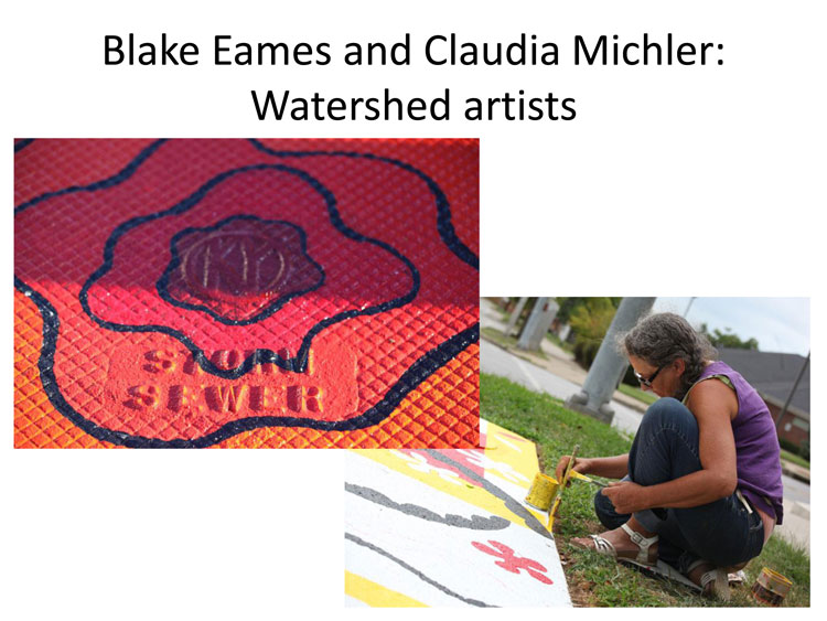
Involved currently are Blake Eames and Claudia Michler, who spent time in 2011 producing storm sewer art in parts of the urban city.
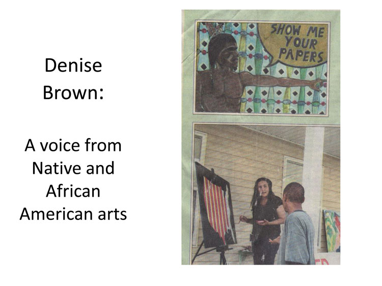
Denise Brown, who I would personally love to have create the first panel of the planned bluegrass-area history mural.
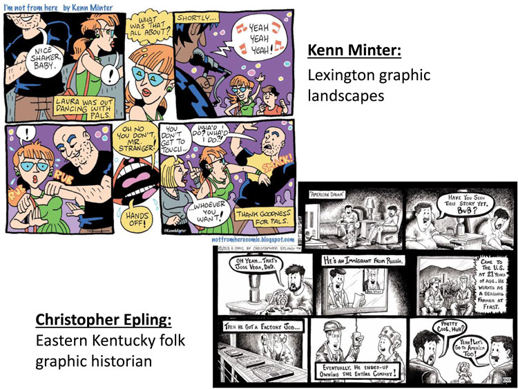
Kenn Minter and Christopher Epling, whose chiaroscuro textures and attention to the modern urban region would both fit will in the history mural or as separate art panels.
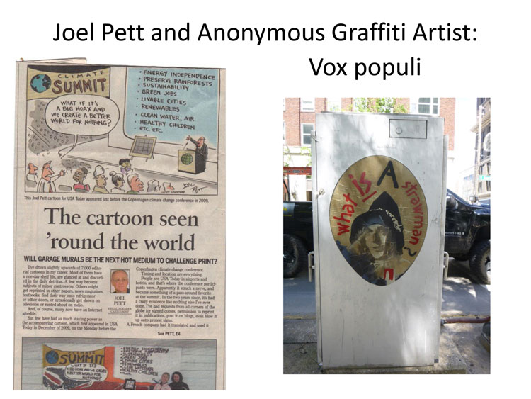
Joel Pett and an Anonymous Graffiti Artist, who (on the recommendation of Transylvania University professors Kurt Gohde and Kremena Todorova) I hope to pair together. Joel has stated that he could draw a history panel and that he’d work for free; for the mural walk, this panel would then be enlarged and interpreted by the Anonymous Graffiti Artist. (I have contacted several graffiti artists, all of whom are cautious to give their names or make any commitments since Mayor Gray has prosecuted several of them, but I am confident I can convince one or two to trust their city representatives on this.)
Phase Four: permaculture trail
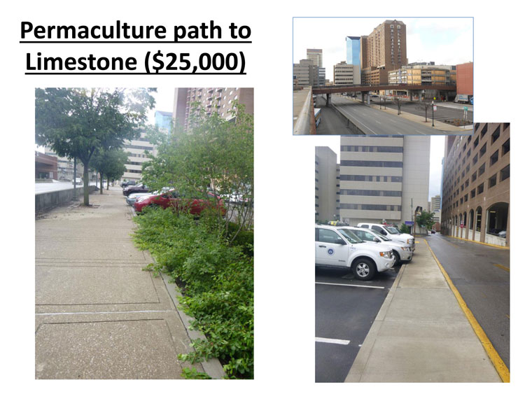
Finally, to connect back into the SAPE designed Town Branch Commons grid, this Mayer’s plan calls for for a heavy green screening of the partially re-claimed lot along Vine Street tor replace the too-wide sidewalk that now runs there.
This final phase also calls for the reclamation of the north-west side of the surface lot. In place of the 35 partially-used spaces now on the site, the plan calls for the construction of a permaculture walking path that will lead away from the viaduct/food truck area and toward Limestone Street. The idea behind the green-screening and permaculture path is to move east/west pedestrian activity away from Vine Street and inward to Water Street, where it might extend naturally into Phoenix Park.
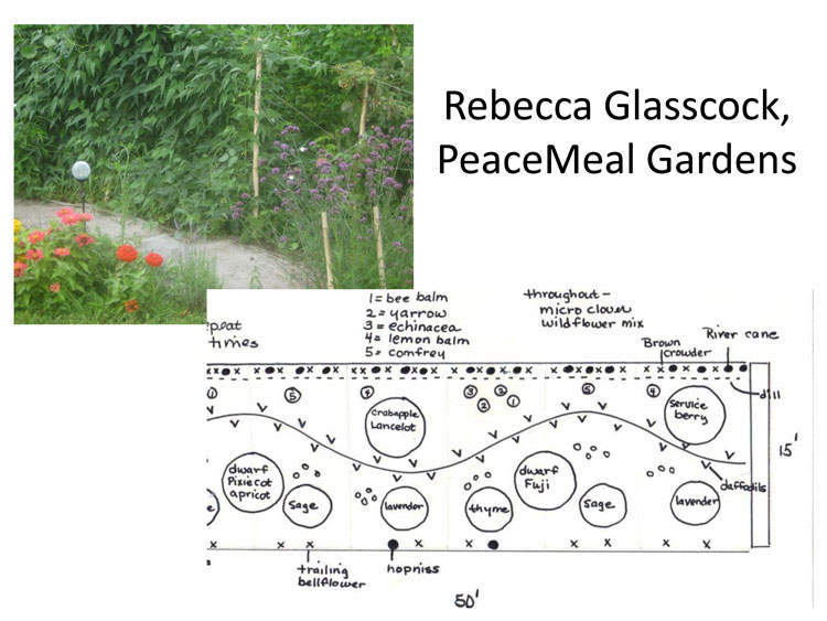
Rebecca Glasscock, along with watershed advocate Ken Cooke and watershed crooner Chris Sullivan, will be joining me to for a more extended hour-long session at Al’s Bar tonight at 7:00. You are all invited. At the talk, Rebecca can tell you all about her work getting certified in Permaculture, or also her work with BCTC’s PeaceMeal Gardens, a several acre patch of land she oversees at my college’s Leestown campus. She, like the other local citizens named in this presentation, would like nothing more than to get to work.
At Al’s, Ken Cooke will discuss his work in the Wolf Run watershed, one of our county’s many watersheds that, unlike downtown’s buried Town Branch creek, have received minimal attention by city leaders. Technically speaking, Wolf Run (and not Town Branch) is Lexington’s founding watershed. The city was named, according to historical record, at the site of McConnell Springs in 1775, a water source that pools and then sinks into the ground, re-emerges nearby at Cardinal Valley’s Preston Springs, and then empties into Wolf Run.
Ken’s talk will open into a discussion of future “watershed parks” that build off the Mayer’s Challenge #FreeLexTran idea. I have invited Ken to talk because he is a passionate and informed local advocate for our city’s watersheds.
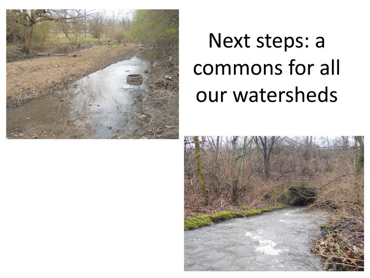
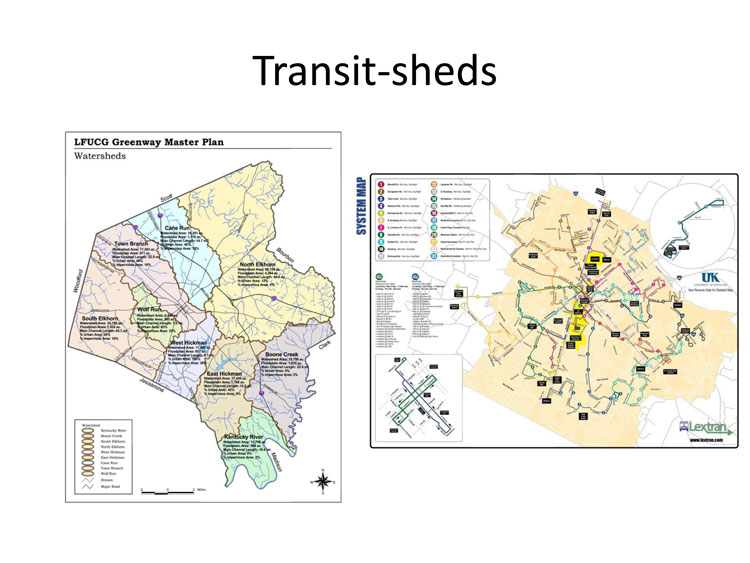
I envision future low-cost, local class, multi-functional design parks for all of our county’s watersheds that are accessible by our LexTran bus routes. Future Mayer’s Challenge design sites will thus map our county watersheds onto our bus routes, to create what I call “transit-sheds.”
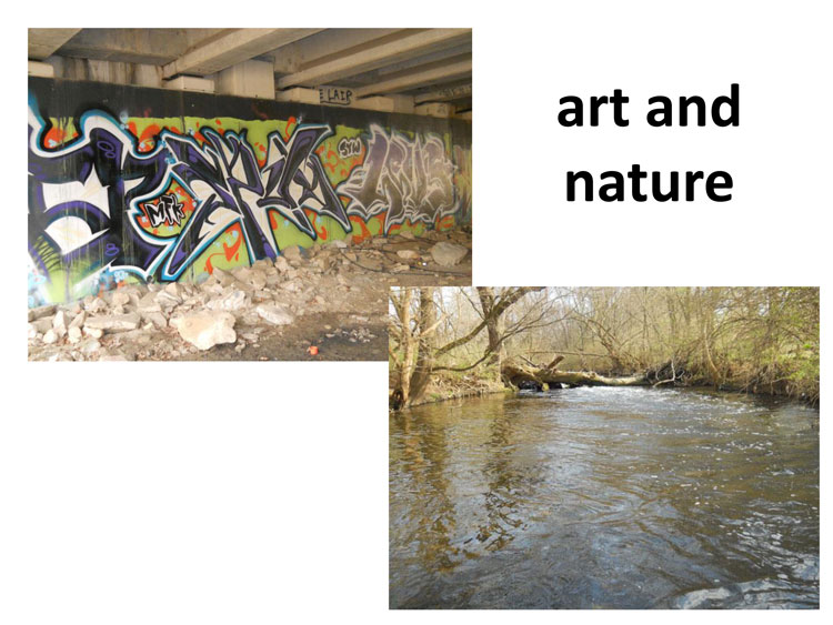
One day, this Mayer has a vision that Fayette commoners and visitors alike might make a day of travelling LexTran to experience the totality of their city’s diverse habitats and watersheds, and to do it in such a way that art and nature, transportation and leisure, and food and activity, can all be enjoyed by the entirety of the city’s residents–and not just downtowners or those in town for a basketball game.
Thanks for letting me talk today.

After the presentation, Mayer was asked one question, by District 3 council member Diane Lawless. It concerned the specific location of lost parking spaces. No other questions were asked. The entire council meeting lasted 32 minutes, from invocation to Mayoral send-off.
Gordon Kaye
As a student at the University of Kentucky and newcomer to the Lexington community, I feel that plans such as these (those generated by local citizens for local citizens) should be more widely publicized. Students at the University of Kentucky, such as myself, are often looking for opportunities to get involved in the wider community. There are enough student organizations to occupy any individual for a lifetime, but outreach regarding initiatives such as this could bring a youth voice into the conversation.