
An undiscovered gem in Eastern Kentucky
By Dave Cooper
The Dawkins Line Rail Trail, in Johnson and Magoffin Counties in eastern Kentucky, officially opened in June – but many Kentuckians still have not heard about it.
This 18-mile-long trail is a little gem in the mountains of eastern Kentucky: it’s our commonwealth’s longest rail trail, it’s in a beautiful and remote area, it’s very peaceful and quiet, and it is in pristine condition.
I first rode this trail solo in late August. I enjoyed the trail so much that I went back the following weekend with my friend Patty and we rode it on a beautiful late summer day with just a hint of fall in the air: the ironweed and the Joe Pye weed along the trail’s edge were in their full glory, and the wooded sections of the trail were nice and cool and shady. The trail is quite beautiful in spots, and it’s a low-key and enjoyable ride that is suitable for families and even small children.
The trail surface is finely crushed gravel, so most cyclists will probably want to ride their mountain bikes. Any tire over 1.5 inches diameter would probably be OK, but thin road bike tires will sink into the gravel. Bikes with front suspension are also recommended, as this trail has some sections with a mild washboard surface. The trail is open to hikers, cyclists and horseback riders, but closed to motorized vehicles including four wheelers, ATVs, motorbikes, etc.
I think this trail would also be fine for a day of low-key hiking or just walking the dog.
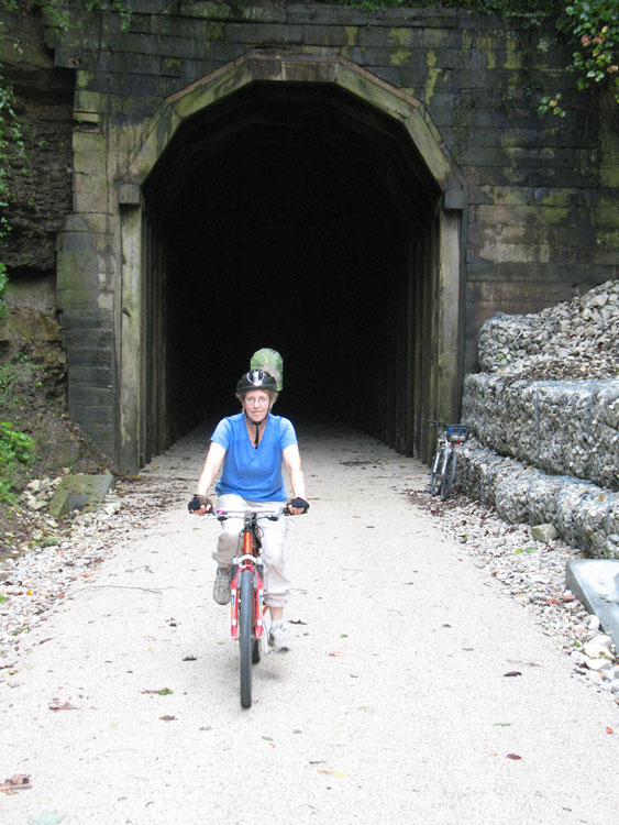
The first section, travelling westbound from US 23 at Hagerhill, is fairly unremarkable. It’s pleasant but not especially beautiful. The trail passes homes and the outlying areas of Paintsville. Past Swamp Branch (Mile Point 8), there is a gradual uphill grade that is barely noticeable and the trail enters the woods. About 5 miles past Swamp Branch the trail crosses over KY 114, the main highway between Salyersville and Prestonsburg. The trail passes through Ivyton, then ascends to the 662-foot long Gun Creek Tunnel.
Gun Creek Tunnel is a good place to stop and take a break. The construction of the tunnel is fascinating: it’s made from massive wooden beams. It looks like it was built to last for two hundred years, but the fortunes of the Dawkins Lumber Company, which began building the railroad line in 1912, evaporated with the stock market crash of 1929. It’s cool and pretty dark inside the tunnel – riders will be glad if they have a headlamp or small flashlight.
After the tunnel (MP 15), the trail gradually descends to Royalton (MP 18) in Magoffin County.
There are plans to extend the trail from Royalton for another 18 miles through the community of Carver and through another impressive tunnel at Tiptop into Breathitt County. The trail will be a total of 36 miles long when completed.
The people who built the Dawkins trail did a good job. It seems to be well-engineered for safety. There are 24 attractive wooden trestles built atop the old iron railroad bridges, and the signage at road crossings has been done well and thoughtfully. However, “wayfinder” road signs are needed on the major regional highways, especially US 23/460, to make more people aware of the trail and to direct them to the trailhead.
Patty and I first explored this part of Magoffin County about five years ago while testing stream water quality in eastern Kentucky. I noticed then that the old railroad bed was being used by four-wheelers as a public trail.
But both times I have ridden the Dawkins Trail I have met a park ranger patrolling the trail. He says there have been very few problems with crime, trail users trespassing on adjacent land, or with four wheelers. As I said, the trail is pristine and I saw no litter or vandalism. Local officials seem to be doing a great job keeping the trail safe and family-friendly.
It is advisable to print the on-line trail map (link below) before heading out on the trail as some of the trail is in a fairly remote area. Trail users should also be advised that there are currently no stores, shelters or even bathrooms along the trail. You should plan to bring water and snacks on your ride. However, there are two small stores at the west end of the trail in Royalton that sell sandwiches, ice cream, soda and snacks.
I expect there will be more services offered as more Kentuckians begin to use the Dawkins trail. I well remember riding the Little Miami Rail Trail near Loveland Ohio (north of Cincinnati) when it was first opened to the public in the 1980’s: It was only 13 miles long, from Loveland to Morrow, not many people used it, and it lacked amenities. But over the last 30 years, the state of Ohio has remained committed to the project, and added 60 miles to the trail, plus rest stops and bathrooms and parking area/trailheads. Local communities and civic groups have built picnic shelters, trailside parks and playgrounds, and ice cream and bike shops have sprung up and thrived. Communities along the trail have embraced the 350,000 people who use the Little Miami Trail annually, and it has greatly added to the quality of life in these trail-side and surrounding communities, as well as promoting physical fitness for the whole family.
Kentucky has spent over $2.5 million on the Dawkins trail, including $500,000 of coal severance money. I think it was money well spent, with an eye towards building the future economy of eastern Kentucky. We certainly need more green tourism and healthy recreational opportunities in Kentucky.
The Dawkins Line Rail Trail at this time may be lightly used, but I don’t expect it will stay that way for long. As this trail becomes more popular, I hope it will encourage Kentucky to finance more bike trail projects.
So go check out the Dawkins Trail, before it gets too crowded!
But wait, that’s not all!
And while you are in the Johnson County area – I recommend visiting the Loretta Lynn homeplace in Butcher Hollow, Van Lear, Kentucky. Just follow the signs from US 23. Loretta Lynn’s younger brother Herman Webb will be glad to give you a tour of the historic Webb family homeplace for a mere $5. This experience is delightful and unforgettable.
Another interesting area attraction is the Mayo Mansion in downtown Paintsville, the colossal 40-room home of coal baron John C.C. Mayo (1864-1914), who developed the “Broad Form Deed” that severed landowners’ mineral rights from their surface rights. The Mayo Mansion was completed in 1912, but Mr. Mayo died only two years later. The mansion is now a school called Our Lady of the Mountains.
To ride the Dawkins Line Rail Trail, below are directions to the easiest trail access point near US 23. Visitors may also wish to consult the Kentucky Gazetteer – go to page 55 and find Paintsville in the upper right of the page, then look for the intersection of US 23/460 and KY 825 just a few miles to the southwest of Paintsville. The old railroad line is marked on the map – it travels south and west into Magoffin County, then south into Breathitt County where it ends just past Evanston.
Directions From Lexington:
Take the Mountain Parkway east from Winchester until it ends in Salyersville. Continue straight on KY 114 for 2-3 miles past the Salyersville commercial strip, then turn left on US 460 east heading towards Paintsville. Travel on US 460 for about 13 miles and then turn right (south) onto US 23. Go 2.5 miles on US 23 south and turn right off the highway onto KY 825. There is a sign for the trail crossing, and visitors can park in a small pull-off space and start biking south and east for another 15 miles to Royalton. (Going the other way, the trail goes towards Hagerhill and Paintsville, following US 23, then dead ends in 2 miles).
Another option is to continue driving on KY 825 for 6 miles to the main trail parking area, which is a large gravel lot big enough to hold two dozen horse trailers. From this point it is about 10 miles in a southwesterly direction to the end of the trail in Royalton.
To learn more about the history of the trail and the Dawkins Lumber Company, or to download a PDF map of the trail, go to http://parks.ky.gov/parks/recreationparks/dawkins-line/default.aspx
timothy honaker
My mother was born and raised near Royalton and lived very near the Dawkins and Elkins lumber mill. I have heard her many times talk about the flood of 1927 which devastated the town and the surrounding community. She would tell about hearing the steam whistle which blew to warn people of the rising waters. She also talked about riding the passenger train which ran daily between Royalton and Paintsville and the passenger and freight depot at Ivyton – a part of which may still be seen at very near the location it was at all those years ago.
timothy honaker
I just read your comments about the Dawking Trail and found it interesting but I beg to differ about the name of tunnel at Ivyton.I have lived within one quarter mile of that tunnel for well over fifty years and have always known it to be referred to as the railroad tunnel at Ivyton. As a matter of fact I have good friend from Ashland who for many years was a detective for CSX and when talking about those days he always refers to it as the Ivyton tunnel. I don’t know what B.S.and K.R, C and O, CSX, or R.J. Corman called the passage through the hill but I think it should be correctly called the Ivyton tunnel.
E A Wills
Yes, the Dawkins Line Rail Trail is a very beautful trail especially in the spring and fall with all of the colors in their glory. When the trail was built, well over a hundred years ago, the builder and his work crew didn’t have the faintest idea that this trail would be used for a bike path. His main goal for the line was to move logs harvested from huge trees to the mill in Royalton where they were turned into lumber for the building trade. The small steam engine used back then had the power to pull a long string of loaded cars but had difficulty in going up grades thus the main reason for Gunn Creek Tunnel. My grandfather who worked for the Dawkins Mill for almost 20 years or until the company’s closing helped build the Gunn Creek Tunnel and many of the bridges still standing today. Just hope that the people along the trail keeps their dogs in check and works with the rangers to keep peace and crime in check!
Regards,
E A Wills
Mokena, IL