

On the Town Branch, part 2
By Danny Mayer
I first heard about the Town Branch in a geography class at the University of Kentucky, early in 2001. We didn’t talk much about the creek itself. It was the thing that oriented us differently on the maps: our skeletal framework, a northwesterly axis, something railroad ties covered.
It would be another six years before Town Branch appeared to me in all its cavernous damp wonder. While visiting a farm in Keene, Kentucky, I happened upon an urban caver and all-around fire-master—a man who introduced himself as “Thom-with-an-H,” the last three syllables rolling away from the lazy ‘m’ like the sharp uncoiling of a lasso (tom,with-in-atche). Over a long fire that spanned several days, Thom-with-an-H recounted to me stories of cave trips taken beneath the greater Lexington substrata. Several of these stories began or ended nearby the Town Branch Creek; a few involved walking up-creek from the edge of the Rupp Arena parking lot, into the culvert, and underneath downtown.
During that summer of 2007, I sat for hours and listened to Thom-with-an-H talk, marveling all the while at the holes his caves were poking into my Lexington maps. It was quite heady stuff to imagine one descending underground at Cardinal Valley and emerging in Southland, or disappearing into the west end of Rupp only to re-appear one block east of the East End.
Thom-with-an-H was a well-meaning and sometimes brilliantly insightful person with a lust for knowledge and a true gift for intensely managing a fire, but he also had a little bit of the Lost Sea Scrolls in him. I was never able to make out if the stories he told were of his travels, of some obscure piece of historical writing (say, George Washington Ranck’s 1872 opus, History of Lexington, Kentucky: Its early Annals and Recent Progress, which mentions the existence of Indian burial grounds located in caves beneath the city), or, indeed, whether the stories he told were imagined suppositions based solely upon a few intensely felt visions experienced whilst pouring over a few area geology maps in the UK Map Library.
But by that time it didn’t matter. The jig was up. In the intervening years between my college lesson and meeting Thom-with-an-H, I’d developed such a nasty habit for traveling the slack waters of the Kentucky River that it was threatening to explode into a full-blown worldview.
By point of current geological fact, the river here as it enters the inner bluegrass carves a nearly 180 degree, 300 foot deep, moat around Lexington. Many eons ago, when the Kentucky cut a northwesterly course on its way out of the Appalachian Mountains and toward confluence with the Ohio River, it passed near present day Lexington. But then a millions-year-long series of upthrusts in the earth’s surface lifted the inner bluegrass above the mainstem of the river. Over time, things moved.

May 2006 hike down Minter’s Branch to Kentucky River. Photo by Danny Mayer.
Geologically, the process is termed an orogeny. This specific orogeny, the Taconic Orogeny, bore the Cincinnati Arch, a rock bulge that runs northeast from Alabama through Nashville, peaks nearby Nicholasville, and then slowly loses height as it passes through its namesake city and splinters its way into Ontario.
As a result of Lexington’s rising foundations, the river here began to stagnate and pool, stretched west and then unnaturally south, feeling all the while for cuts through the uplift and otherwise scouring its way back into a northwesterly kind of flow. Which it did, many more millions of years ago, at a point not far from present day Camp Nelson, 25 miles south of Lexington. To look on the area now from a satellite map is to see Lexington sitting centered atop a palisaded south-reaching peninsula with a radius holding steady at an erratic 25-35 miles distance from Lexington’s CentrePointe. For a flowering river rat like myself, this quirk of geological history was a lucky gift, a surfeit of water outlets all located within a 45 minute drive.
By 2007, I had paddled the Elkhorn’s forks, and Boone after a heavy rain. I had hiked sharply-cut, nearly-no name creeks like Minter’s Branch from source to mouth, and no-name ones that tumbled into the ruins of eighteenth century mills to swimming holes hidden beneath a state highway rumbling a century of feet above. By 2007, I was already jumping headfirst into the cold waters of the Dix, conducting rural night-time hunts for spring houses outside Wilmore, and spending summer nights with fellow river rats bobbing in a john boat beneath the stone gaze of the Seven Sisters on Pool 7 of the Kentucky—just because we could—a peanut butter sandwich and six beers in stow to tide us through sunrise.
By the time Thom-with-an-H was telling me about caving Town Branch, it didn’t matter how factually his stories were. They felt real. I had walked enough cuts, descended enough karst geology, stepped around enough springs and contemplated enough water flow to know that something was there, that whatever it was was wondrous, and that whatever its wonder, it likely lay just out of view or focus from straight-seeing eyes.
The beauty of all rivers, and this is especially true of those in Central Kentucky, lies in their cut. To be on the river is to descend into the earth, to pass below banks and beneath view. For a variety of reasons, this perspective is radically freeing and, as Tom-with-an-H was beginning to make clear to me, readily available to all Fayette Countians if only we knew what to look for–and where to look.
I don’t know what to make of this story, other than that I feel compelled to offer it, and perhaps use it to underscore what may not be evident otherwise, which is that I should be one of the primary supporters of the proposed Town Branch Commons, the linear urban park that will stretch from Rupp Arena to Isaac Murphy Memorial Park. I should love that the plan by Scape Landscape Architects entrenches a city commitment to public space—a commons—that has the byproduct effect of proclaiming and celebrating waterways as places deserving of our civic, social and environmental respect and care.
Beyond my specific water interests, though, I should also love that the project reflects and celebrates my interest in Lexington history. As a downtowner, I should love its urban location and its threading together of Rupp Arena and the East End’s Isaac Murphy Memorial Park, the latter a short walk from my home. A biker and sub-urban hiker of area lands, I should love its connections to the proposed Town Branch bike trail, a path that first will take me to a different public park located in a different locally historic watershed, McConnel’s Springs flowing into the Wolf Run Watershed, and then beyond that to a pastoral countryside. I should love that the plan itself is gorgeously rendered, environmentally conceived, for the most part practical and—above all else—generally committed to the public commoning of unproductive or poorly used land.
And. I. Do. Love. All. Those. Things.
But I think that misses the point entirely.
World class and local class
The dominant narrative surrounding the selection of Scape Architecture’s plans for the Town Branch Commons is that they are a byproduct of Lexington finally thinking big and swinging for the (global) fences. This narrative, largely redemptive, sprang to life during the World Equestrian Game buildup—over $100 million and five years in public investments for 10 days of the city presenting itself to “the world.” But it has really taken off during Jim Gray’s reign as Mayor.
The most updated version goes something like this: At the early fevered moments of economic decline during the late-Bush years, before the real panic set in, real estate developers Dudley and Woodford Webb callously destroyed the city’s central downtown block in a failed bid to construct a generically massive office/condo tower, an act which sparked a new generation of urban activists who, in 2010, elected a different Mayor who “got it.” Said Mayor has inspired new confidence in downtown by creating a synergy with local actors who are also big thinkers. Together, these important actors have attracted really important global actors—design people, business people, artists, academics—to forge an authentic and world class plan to move the city into tomorrow. Synergizing all that energy is a bold plan to redevelop 50 acres around Rupp Arena, an act which promises to act as both stimulant and complement to new private investment attracted to a now-booming downtown.
Here’s a generally representative version, this by Tom Eblen in an article describing why the Scape proposal for the Town Branch Commons was “the most authentic to Lexington.”
“How could little Lexington attract such talent? One reason is the personal connections Michael Speaks, dean of the University of Kentucky College of Design, has in the global design community. Another is Mayor Jim Gray’s vision for a world-class downtown. And another is the successful Arena, Arts and Entertainment District Task Force process, which engaged a world-class master planner (Norway-based Space Group) and is now following through on its recommendations. Lexington has a lot of work to do before these grand plans can become reality. But, for the first time in a very long time, it at least has some truly grand plans.”
As a teacher of rhetoric (er…ENG 101), what stands out to me is the implied comparisons between Lexington and other places. Lexington is “little,” and it “has a lot of work to do,” in part because until recently it has generally been unable to attract “such” talent, a description applied liberally to things that are “world class.” This term, world class (cognate: global), seems to refer generally to something important and large. Beyond that, the term’s primary reference shifts. At times, it categorizes, certifies and grades, the development equivalent of Grade A 100% All Natural Organic Beef. At others, world-class connotes cosmopolitan urbanity, a thing to contrast with vulgar suburbanism.
Of course, the word is also a location, a someplace not here where people and things are generally better. Thus, “world-class master planner” Gary Bates is such based on his corporate home in Norway. Kate Orff has it because she’s headquartered in the global city of New York. Jeannie Gang, whose authentic idea for Lexington involved stable (as in horse stable) architecture, gets it for winning a globally respected genius prize (the Macarthur Prize). But for Lexington-bound leaders, excellence must by definition come from somewhere else. The local college design professor attracts “such” talent because he has “personal connections…in the global design community.” The local Mayor gets it because he flaunts a gigantic “vision for a world-class downtown.”
The effect is to create a distortion of value between world-class and, as it were, local-class. We are told by leaders with world-vision that our town is not urban enough, that it lacks a good enough convention center, that it needs an arts center and more parks, mis-uses one-way streets, needs a boutique hotel, lacks a defining downtown landscape, and most recently, that it does not have a strong enough water presence to be able to realistically consider itself a truly great American city. Listening to our leaders talk, it’s hard not to feel like a verbally abused kid whose parents always compare them to the dipshit Harvard-bound cousins living down the block.
Here’s one leader describing why the Town Branch Commons are good for us: “Lexington is one of few American cities without a body of water or piece of compelling landscape to give it a sense of place…Like a well in the desert, our downtown is so small and intimate that every option for maximizing its quality and economic potential is essential to pursue.”
Locate that metaphor. Downtown is a well, around it is a desert. Where are you in this geography?
Re-telling local stories
Of course, nowhere in Fayette County resembles a desert. Like the back of a vein-throbbing hand, the county sits atop a fistful of watersheds, and they run through most of our neighborhoods. This is the second problem with the narrative of Lexington’s world-class resurgence: it doesn’t really tell the truth, it imposes it. The origins of Town Branch are no exception.
In October 2005, Lexington Vice-Mayor Mike Scanlon appointed a city task force to “further define the existing vision for a ‘linear park’ on Vine Street.” The task force featured several council members, Lexington Downtown Development Authority president Harold Tate, developer Phil Holoubek, and former mayor Foster Pettit. It was chaired by urban landscape designer Steve Austin, who worked for the city’s Bluegrass Community Foundation. With interests in public greenways constructed around waterways, urban environmental design, and (later) biking, Austin was a wise choice to head the group.
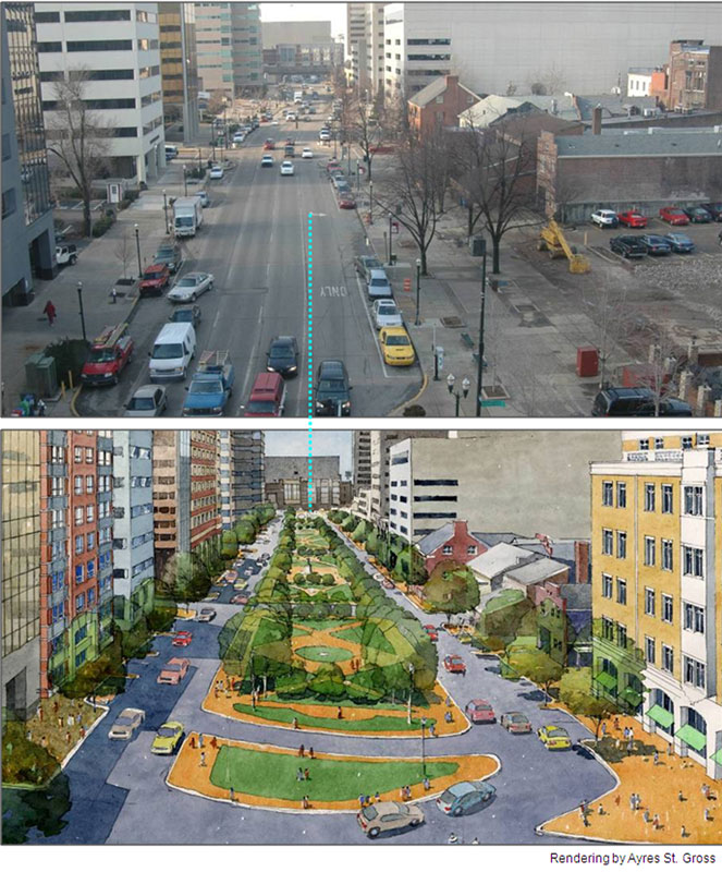
Design proposal for Vine Street rendered by Ayres St. Gross for 2006 Vine Street Linear Park LFUCG Task Force final report.
In August 2006, two years before the CentrePointe block came down, five years before Master Planner Gary Bates issued a Downtown Plan that envisioned a Town Branch Commons threading through town, and seven years before Kate Orff’s Scape proposal symbolically reconstructed the creek to run along Vine from Midland to Oliver Lewis Way, Austin presented city council with a 24-page report. In it, he and the other Lexington members of the panel argued for a “Vine Street ‘linear park’ [to] be connected to the Town Branch Trail planned for west of downtown, or other greenspace as planned in LFUCG’s Greenways Master Plan.”
Map images of the 1804 Commons running downtown along Water Street appear first on page two of the report. On page eight, the report suggests not raising Town Branch to the surface, but instead “including water features that are representative of the Town Branch.” It concludes, “[t]he concept is historically accurate. It takes us back to a time when Vine Street was referred to as ‘The Commons,’ the Town Branch was an open canal, and this area was a major congregating place for citizens.” Though it advocates no specific designs—calling instead for a national search of the kind SCAPE recently won—the report did offer various sketch ideas, one of which (also first appearing on page two) looks quite similar to the Orff/Scape design.
Austin, along with the commission he chaired, has been mostly written out of the triumphant story of Lexington’s new world-class plans. But then again, admitting him into the story changes the narrative. Without him, we can cheer on (soon pay for) a world-class landscape architect’s authentic vision for the city; with him and others who contributed to the vision, and it looks like many of the world class ideas were generated a half-dozen years ago by a local city council ad-hoc committee operating under a conservative vice-mayor at the height of the irrationally exuberant Bush years. In a city proclaiming its progressive spirit, is that sort of progress worth all the fuss?
Different values
OK, I know what you are thinking. Delayed victory, good things take time to convince the “people.” The Orff design kicks ass. All true.
But take a look at what gets valued in the choice. World class has done well. It authorizes the $150 million “gold standard” upgrades to Rupp Arena; it’s giving downtown businessmen an upgraded convention center to show off to their buddies in Chicago. Already, within a week of proclaiming that “the people I’m talking to are taking notice of Lexington,” UK Architecture Dean Michael Speaks leveraged his connections for a new job in Syracuse. Meanwhile, up-and-coming landscape architect Kate Orff will be returning shortly to Lexington from her home in New York to further develop her big plans for the commons (and, presumably, to pick up an equally sized paycheck).
And Steve Austin? Austin, who moved to Lexington as a teen in the early 1980s, lost his position with the city in 2012, about six months before it hired UK double-retiree Frank Butler at $250,000 a year to manage the Rupp Master Plan developed by world-class master planner Gary Bates (and, presumably, now also to interface with Town Branch Commons designer Kate Orff). Amazingly, though he chaired the task force that first officially introduced the now-hot Town Branch idea, Austin was let go by an administration publicly concerned with keeping and celebrating local talent in emerging fields.
This is a shame, but one that is not entirely a surprise. Austin was one of the few people in this city taking a vocally active interest in truly sustainable practices. He was the only public official I know of wo was biking streets throughout the city to think of alternative pathways of transportation. He was also one of the most attuned to planning in the age of anthrogenic climate change. Austin’s now kicking around Europe, building upon the interests he first began to develop while in Lexington: sustainable development and low carbon urban designs—an occupational focus for which the New Yorker Orff has been lauded as an emerging global leader.
Update: Steve Austin wrote in with a little bit of context on his leaving the Bluegrass Community Foundation. He writes, “I wasn’t let go by the city as I never worked for them. The grant I was working under at the community foundation was ending and they let [my coworker and I] go before it did so they could do whatever with the rest of the grant money.”
Leave a Reply