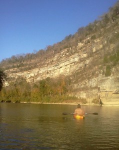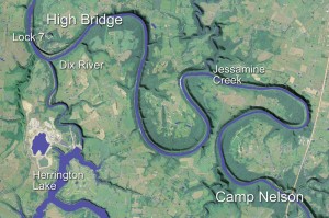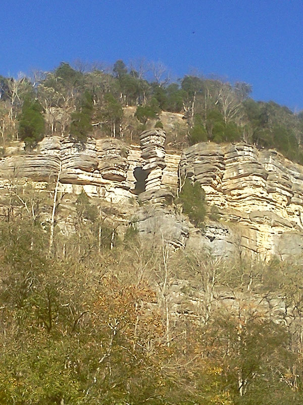
Entering straightaway around Polly’s Bend, Swallow Rock on the palisades to the right, Jessamine County.
Camp Nelson to High Bridge
By Wesley Houp
Our put-in is Camp Nelson, a smattering of water-weary shanties, trailers, and RVs pinched between river and road in what can only be considered loose apposition to any sense of the term “community.” We park Danny’s ramshackle Isuzu under Lloyd Murphy Memorial Bridge on U.S. 27 (mile 135 on the Kentucky), unload and shuttle canoes and gear down the crumbling concrete ramp, and within twenty minutes we are on the water, shuffling and restowing dry bags, resolving vagaries of trim and draft.
Downstream and northwest, the river disappears around the sharp bend, a leading edge of palisades opening where the Camp Nelson bottom finally tapers to steep, wooded talus. The striated face of Ordovician limestone glows, as if back-lit, in rarefied October light, its gold deepening the sky’s sapphire. It’s nearly three o’clock; we’re off to a late start, and with eleven miles to paddle, our chance of making Jessamine Creek gorge—our preferred bivouac—before dusk is slim. A stout headwind dials up the drag, and we push a little harder. Fortunately, the Kentucky’s deep meanders offer intermittent reprieve from the gust. Just around the bend, we find a casual pace and enter one of the most remote and dramatic riverscapes in the eastern United States.
Inherited entrenched meander
The twenty-mile series of bends below Camp Nelson represent what geologists call “inherited entrenched meanders.” Willard Rouse Jillson, Kentucky’s state geologist in the early decades of the twentieth century, hypothesized that the Kentucky River’s ancestral headwaters lay far to the southeast in present-day North Carolina. These source streams, what is now the Watauga River watershed, were effectively beheaded and diverted into the southwest-flowing Holston and French Broad watersheds through successive periods of regional uplift, crustal warping, and faulting during the Mesozoic and Cenozoic eras. All told, the Kentucky lost approximately 3000 square miles of watershed. The topographic results of uplift were Pine and Cumberland Mountains, long, straight anticlinal ridges extending southwest to northeast. The uplift concluded some 50 million years ago, and the beheaded (and greatly diminished) Kentucky River captured new headwater streams from the northeast face of Pine Mountain.
The loss of water volume influenced the river’s course, particularly in its lower stretches, where the corresponding topographic character was largely featureless peneplain, extending uninterrupted into salty marshland of the old gulf (of Mexico) embayment. Numerous channels were abandoned and new channels were carved. These redirections are known as “process meanders,” formed by the post-uplift, revived Kentucky River. But in certain upper and middle stretches the river had already abraded its bed so much so that abandonment was impossible. So the present-day Kentucky represents both an “antecedent” and “consequent” stream. Down in these deep abrasions, these inherited entrenched meanders, the contemporary paddler is boxed in the ancient, antecedent Kentucky. Here, the palisades offer awe-inspiring stratigraphy, a vertical portrait of geologic time extending back (and down) through the Paleozoic world.
It’s humanly impossible to imagine the Ordovician world in anything other than gross abstractions. Continental Drift—the understanding that the Earth’s mantle is fluid and that the Earth’s crust, i.e. continental plates, move around like cosmically sluggish ships powered by the heat of the mantle’s convection—is a layman’s term for some bewildering geo-goings-on. Back then, half a billion years ago or so, the major continents, Gondwana, Laurentia, and Baltica, were drifting ever so slowly toward their critical mass, the supercontinent Pangaea, a destination still some 270 million years away. Deep oceans covered Ordovician Earth, and great swaths of the continents themselves steeped in warm, shallow seas. This was a shellfish planet, a planet where the delineation of plant and animal kingdoms wasn’t so visually distinct, one hundred million years before the oldest ancestor of fishes emerged. brachiopods, brachiospongia, bryozoans, cephalopods, crinoids, cystoids, gastropods, trilobites, and a menagerie of other small creatures dominated aquatic life while primitive mosses accounted for most of the greenery on land. The earth, at 3.5 billion years old, was still too young even for insects.
Once the continents had amassed and formed Pangaea (at the end of the Paleozoic era some 230 million years ago), the Teays River system, of which the ancient Kentucky was part, had formed as a result of Taconic Orogeny, the great mountain-building event that gave rise to the Appalachians. The ancient Kentucky helped drain the mountain waters into a shallow inland seaway that stretched across the heart of the North American continental plate—the confluence of the Mowry Sea breaching down from the north and the Tethys Sea swelling up from the south. By this time, remnants of the Ordovician period lay beneath the collective sediments of the Silurian, Devonian, Mississippian, Pennsylvanian, and Permian periods.
In the Bluegrass a Pliocene reverberation of that distant orogeny, known as the Cincinnati Arch—a cataclysmic event that forced the region of central Kentucky violently upward and left many faults and fissures—allowed the uplifted and overlaying strata to erode, and by the Pleistocene the Ordovician world reemerged from primal sleep. The Kentucky, which originally flowed over the arch, found redirection around the south side of the “Jessamine Dome”—the highest point of the arch—exposing layer upon layer of compacted past.
Two miles into our journey we beach on White Oak Bar, a prominent towhead at the mouth of an otherwise diminutive White Oak Creek, one of countless, spring-fed capillaries to rise atop the peneplain, slice a narrow gorge, and debouch its waters in the Kentucky. On bars like this, amateur rock-hounds can recover (with relative ease and without sophisticated implements) the remnants of ancient life. Within minutes, I’ve collected a handful of brachiopods, Platystrophia by genera to be precise.
Platystrophia and butter churns
Henry’s Pocket Fossils book informs me that Brachiopods were “the common shellfish in ancient seas,” living on the seafloors, filtering their food from the water. The brief description concludes with glib, Darwinian fact: “Since the beginning of the Mesozoic era, they have largely been replaced by bivalve mollusks.” Henry, my son, is nearly five years old, and prehistoric shellfish extinction is neither a glib nor substantially formal proposition. Brachiopod fossils (particularly platystrophia, which I have collected in abundance) are simply “really neat-o.” Like me, he is partial to those specimens most intact, the ones preserving their deep fold (the slightly raised mid-section of ribs fanning from beak to curve) that helped them maintain a constant stream of water—and food—flowing between their two shells.
But brachiopods aren’t the only remnants of past life to be recovered here. An old cabin used to sit in the bottom at White Oak Creek, set in the overgrown woods off the river. Back in the late-50s, years before the record-breaking floods of ’72 and ’78, my father, in the height of his wanderlust, frequented the long-abandoned homestead while running his trap-lines along the 24-mile lock 7 pool. For the most part, he recalls, the cabin had been long since emptied of its artifacts. The only item he recovered—and kept—was a common dash butter churn constructed of ash staves and brass bands. Apparently, similar churns could be had from Sears and Roebuck for a mere 53 cents, but by 1908 such domestic technology had disappeared from their catalog altogether. The White Oak Creek churn has adorned a corner of the Houp household ever since. My sister and I used to play on the churn, working its handle up and down, calling in affected, sing-songy voices for the butter to “come” from its magical wooden barrel. We also mistakenly attributed the antique to our own great-grandmother, Haggie Mae Horn; I only learned recently of the churn’s true provenance.
An old photograph, a young geologist and evolution
Two miles downstream from White Oak Bar, past Buzzard Bar on the right, Candle Stick Rock looms high on the palisades at the leading edge of Polly’s Bend. In 1920, a 30 year-old geologist named Willard Rouse Jillson posed for a photograph at the base of Candle Stick Rock, a nimble 45-foot pillar of limestone standing out and protruding up from mineral- stained cliffs some three hundred feet above the river. Over millions of years the combined forces of wind and water, working around and behind what must have been a vertically oriented fold of limestone, left what appears now as a precariously stacked chimney. Erosion around and between each stratum of limestone gives the illusion of individual boulders frozen in a Paleozoic balancing act. And there, in the black and white photo, stands a self-confident Jillson, all cavalier five-foot whatever, his jacket unbuttoned, left hand in trouser pocket, and ranger’s hat cocked ever-so-slightly on his head. In the foreground, another stiff-brimmed, dusty ranger’s hat and opened rucksack, dropped haphazardly on the narrow, sloping limestone ledge, presumably effects of the unseen photographer, suggest a hastily planned portrait. The two of them, Jillson and his companion, are literally on the brink of a 400 million year freefall.
Born in Syracuse, New York in 1890, Jillson studied geology at Syracuse University, graduated in 1912, and spent the next five years working as a field geologist for the petroleum industry. With his brothers, Jillson surveyed and invested in the burgeoning oil fields in Kansas, Oklahoma, and Texas, an early professional direction that would have significant implications later for his adopted home in Kentucky, where he settled in 1917, married a good Floyd County girl, and used his academically-enhanced but natural talents to dowse the depths for the burgeoning oil and coal industries. After a brief stint teaching geology at the University of Kentucky, Jillson was appointed Deputy Commissioner of Geology in 1919 by Governor Augustus O. Stanley and in 1920 directed the 6th Kentucky Geological Survey. He held the post of State Geologist for the next 12 years.
The photograph of Jillson at Candle Stick Rock, like hundreds of others taken in the field during the Geological Survey, captured the man at the beginning of what would become a prolific career not only as a field geologist but as a writer. From his initial appointment as Deputy Commissioner in 1919 to his death in 1975, Jillson published hundreds of articles in hundreds of scientific journals, in addition to numerous monographs. His writing wasn’t limited to science; he published biographies of Edwin P. Morrow, the 40th Governor of Kentucky, Paul Sawyier, Kentucky’s celebrated impressionist painter, and Daniel Boone; he collected and anthologized “youthful rhymes and verse”; he wrote regional and local histories; he documented Kentucky’s major literary figures and works. His interests cut across historical periods, academic disciplines, and the domains of life. Of most pertinence here is his book on the river, The Kentucky River: An Outline of Drainage Modification of a Master Stream During Geologic Time, published in 1945.
The Kentucky River Valley must have represented El Dorado for a young and ambitious geologist. The approximately 100-mile stretch of palisades offered relatively easy access to the region’s oldest (and arguably most interesting) geologic structures, not to mention early settlement history, and Jillson, evidenced by the flurry of writing beginning in 1919, dove in headfirst. So much of his writing is of little interest to literary scholars; his prose is that of a consummate scientist speaking to other scientists. In The Kentucky River, Jillson’s concerns are Cretaceous headwater diversions, Tertiary stream piracies and Pliocene period drainage modifications—riveting subject matter for neither public masses nor literary elites. But interspersed throughout, we glimpse the scientist waxing philosopher waxing citizen:
While it is the purpose of this little volume to outline and describe the principal changes the Kentucky river has met during the geologic past, it is hoped that all lovers of nature who turn to the beautiful, but rugged valley of the Kentucky for their moments of out-of-door leisure, will find in these pages a somewhat expanded vista into the largely inscrutable order of the universe.
and later
It is, therefore, perhaps a melancholy, but none the less impressive thought, that in the undoubtedly long period of time ahead, when man and his civilization, which has found a dependable way to read the record of the geologic past, has, like many another once dominant form of life on this earth, passed entirely away, the Kentucky river still governed by immutable geologic laws, again unappreciated and unknown, will continue to sweep on in its ever changing valley while eastern continental North America shall endure!
As he did throughout his career, Jillson preferred the long view. He was a man of his time, a positivist. His long view was forged in science, an intimate reading of the physical earth; however, his “objective” understanding of the truth of the cosmos was tempered by Christian teachings. When pressed on the matter, he sounds consummately Jeffersonian. Science leads the intellect, while religious teachings hold the potential to mold morality. His editorial in The Lexington Herald from 1922 opens with unambiguous denunciation: “Let the ignorant and uninformed deny it whenever or wherever they will, the fundamental principles of organic evolution are indisputable” and “do not need to be defended.” In short, these principles “are above argument.” Yet in the next breath he acknowledges “Christ-like attitudes and broad evolutionary understandings are not incompatible. Jesus said, ‘Ye shall know the truth, and the truth shall make you free.’” He closes his “Thoughts on Evolution” with compromise:
It is a demonstrable fact that the foremost evolutionists of America are good and godly men, highly respected in their communities and by the world. Would that all our Kentucky youth were more like them, as high in their ideals, as broad and useful in their role of service, and as upright and as Christ-like in their physical and mental relations to themselves and to mankind.
All told, his scholarly background in geosciences and his passionate understanding of geomorphology (particularly in the Kentucky River valley) tell him that the Earth and all its creatures are inextricably bound together in chains of events stretching back billions of years, but his upbringing and general respect for the institution of Christianity tell him that the human capacity for the rational, the ethical, and the moral is only enriched by religious observance. The confident man in the photo—the dashing young scientist, balancing on a narrow ledge high above an ancient river with Candle Stick Rock balancing its top-heavy burden beside him—was undaunted by the psychic balancing act of science and religion. Leave truth to science and moral teaching to god.


Buck Edwards
Hot damn, that’s a good-lookin’ map!