
Planning for 2-way Lex
By David Shattuck
The $465,000 “Traffic Movement & Revitalization Study” is now underway. LFUCG gave final approval to the contract with Santec (formerly Entran) in mid-May. According to its contract, the Santec study will “assess the ability of the Downtown Lexington street system to accommodate current and future year traffic conditions with all existing one-way streets converted to two-way operation.” More specifically, “The study will help to determine if two-way conversion can reduce driver confusion, increase accessibility to downtown businesses, and moderate vehicle speeds for improved safety.”
One word that can’t be found in the contract for the “Traffic Movement & Revitalization Study” is “revitalization.” Indeed, an oft-repeated word in the contract is “mitigation”—a lessening, moderation—as in mitigating the traffic congestion caused by converting our downtown one-way streets to two-way traffic. Other “r” words, however, are repeated throughout the contract: roundabouts, right-of-way purchases, and a relocation of the Transit Center.
The Traffic Movement & Revitalization Study
The current study is designed in part to answer the central question I’ve asked planners for over a decade: if 2-way conversion does occur, where will all the traffic go? As Palmer Engineering, one of the 5 firms which responded to the Request for Proposals, wrote:
“The distinguishing feature of the Lexington conversion project, however is the fact that traffic counts on primary arteries will significantly change as the result of converting the one-way streets to two-way operation. This fact leads to an important observation: The single most important traffic modeling activity on this project is to accurately predict how driver behavior and traffic counts will change during peak periods as the result of the street conversions.”
Significantly, Palmer cautions that the traffic model currently in use by Lexington’s Metropolitan Planning Organization (MPO) “does not contain sufficient detail in the downtown area for the needs of this study. Without modification, this model would not accurately predict the diversions that will result from the street conversions.” Accordingly, Santec promises that the “travel demand model will be updated by the KYTC concurrent with this study.”
To minimize the traffic congestion that will ensue in the event that downtown’s one-way streets are converted to two-way traffic, planners apparently are relying on three “Rs”: relocation, rotaries (or roundabouts), and right-of-way access purchases. Relocation refers to the Transit Center, since a 2007 Santec-authored Traffic Study concluded that conversion of Vine isn’t really feasible unless the Center is moved. Roundabouts, or rotaries, appear to be the plan for connecting Main and Vine at both ends of downtown, “hot spots”—or areas where peak traffic congestion would be unacceptable—according to the 2007 Study. Purchasing right-of-way access at other hot spots is the third way planners hope to make conversion work. Let’s briefly analyze each of these strategies.
Relocation: the Transit Center
The 2007 study demonstrated that conversion of Vine isn’t feasible unless the Transit Center is relocated; yet nobody had suggested relocating the Transit Center prior to the conclusion of that study. In its response to the Request for Proposals (“RFP”) for the $465,000 study it will soon begin, Santec asserts: “There is growing sentiment that the transit center should be relocated from its current location on Vine Street. While opinions vary on where the new location should be, the current location is not considered very accessible or safe, particularly for pedestrians.” This assertion is disingenuous.
That the Center is “not considered very accessible” would be considered surprising news by the planners that chose to locate the Center on Vine in the dead center of a now-growing downtown. There is no “growing sentiment” for removal. The truth is it never dawned on anyone in this town that the Transit Center isn’t perfectly located.
I’ve followed events closely since 2001 when planners suggested closing the Vine Street curve, and there has been absolutely no public discussion (say, in local media) about relocating the Transit Center. In response to an open records request in May 2009, LexTran advised me that it was unaware of any plans to relocate the Transit Center (although LFUCG had submitted a request for $20 million in federal stimulus money to relocate the Center). It’s difficult to fathom that sentiment for relocating the center has moved from non-existent in mid-2009 to “growing” by the end of 2011, despite virtually no public discussion on the matter. It’s a similar tactic that 2-way conversion proponents used in 2001 during their last attempt at street conversion. Now, as back then, this so-called “growing sentiment” was created by and confined to a few movers and shakers, who somehow sold planners on these “sentiments.”
One would think, for example, that such growing sentiment would have made it into the Downtown Master Plan, released in 2006. The Master Plan has served as the basis for all discussions relating to street conversion since its release. Yet it makes no mention of needing to move the Center. It wasn’t until release of the 2007 traffic study, months after the Master Plan was completed, that it occurred to anyone that the Transit Center should be relocated. Since the 2007 study has received little reportage and merited little public discussion, any “growing sentiment” is necessarily confined to those planners and big shots who seem determined to monkey with our streets.
Where planners might want to relocate the Transit Center, and at what cost, nobody has yet bothered to share with the public. All we know is that in 2009 Lexington requested $20 million in federal stimulus funds for the purpose of relocating the Center. How the $20 million was calculated is anyone’s guess. When I first learned of this in early 2009 I contacted the Transit Center authorities and was advised that the Center itself had no such plans. The story is murky, but so far this has been clear: when planners mention the cost of street conversion, they fail to include the cost of relocating the Transit Center.

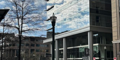
Will Triangle Park become Triangle Circle? Photo by Danny Mayer.
Santec appears to be privy to information that has never been made public. The study promises that its “evaluation of alternatives will include the identification of future projects and developments that will affect traffic flow . . . . these will include renovations to Rupp Arena and the Lexington Center, the Centre Pointe Development, relocation of the Transit Center and potential construction of towers in the current location, and other downtown developments” (italics mine). Towers??? Not cell-phone towers, but more likely high-rise condos.
Roundabouts: CVS & Triangle Circle
The contract, as well as responses to the Request for Proposals, suggest that roundabouts, or rotaries, will be suggested to connect Main and Vine at the east and west ends. Technically a roundabout involves a slight elevation to slow traffic before the circle, while a rotary does not. So imagine a large circle across from the Herald-Leader building where traffic approaches from the west and east (Richmond and Winchester Roads) and meets traffic approaching from Main and Vine Streets in the other directions. Similarly, at the west end Triangle Park might serve as a (triangular) rotary connecting Main, Vine and Broadway.
Rotaries might keep traffic flowing, so long as no pedestrians attempted to cross any of these streets. For when pedestrians enter the picture, so do traffic signals, and traffic backs up in all directions, particularly during peak hours and special events. In any event, even with a rotary recall that conversion of one-way streets results in a substantial reduction in traffic capacity. So it is unclear how an honest simulation model would forecast significant reduction in traffic congestion via rotaries connecting Main and Vine (and the other streets) at the east and west ends.
Right-of-ways: bye-bye foodtruck central
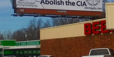
Even if a rotary was a feasible way of joining streets on the east end (Main, Vine, Winchester), LFUCG would have to purchase the right-of-way that is currently the vacant lot there. A sign boasts that this lot represents prime com

Phil Holoubek has land for lease on potential site of potential city roundabout. Photo by Danny Mayer.
mercial space, a gateway to downtown. The site was purchased in 2008 by Main and Vine Partners, LLC for either $1 million or $2.8 million (both sales are listed on the Fayette County PVA site on the date January 15, 2008). The group promptly tore down the structure on the lot to attract retail inve
stment. Recall that CVS wanted to put a drugstore there, but LFUCG decreed that the entrance to our downtown should be something other than a big box. CVS then proposed a design that LFUCG typically would approve if located elsewhere; still LFUCG turned CVS away. Currently, the empty lot’s taxable value is listed as $895,000. Perhaps LFUCG turned away CVS hoping that it could acquire the property in order to connect Main and Vine as part of the Master Plan’s call for conversion of all downtown streets to two-way traffic. One must wonder, how much would it cost to acquire this newly cleared precious piece of property?
When conversion proponents talk about the cost of conversion (I’ve heard estimates of $25 million) they typically de-emphasize or omit entirely things like the cost to acquire rights-of-way. The responses to the RFP indicate, however, t
hat conversion cannot possibly work without major right-of-way purchases at all of the “hot spots” identified in the 2007 Traffic Study.
The contract calls for Santec to deliver its Final Report at the end of next May. Stay tuned. In a future column I’ll continue to analyze these issues and propose an alternative to street conversion to help revitalize our downtown.
The Lexington Streetsweeper
The LFUCG did not turn back the CVS development. Far from it, the Board of Adjustment approved of it and only required an acceptable building facade. Ironically, the BoA would not have even been involved had the CVS not demanded a drive through window. What actually killed the CVS plan was the underground electrical transmission line being too close to the foundation and CVS not wanting to pay the $1 million cost to move it.
The company formerly known as ENTRAN is actually called Stantec.
How many other erroneous “facts” or opinions are there in this piece?
Danny
Sweeper,
Thanks for the correct spelling, but are you stating that calling Stantec “Santec” (ie, leaving out a “t”) is an “erroneous ‘fact”‘? That seems stretching things, no? In case you missed it, here’s an earlier piece that identifies Santec (again, no “t”) as the former Entran.
https://noclexington.com/?p=6954
Thanks also for the clarification on the BoA approval of CVS designs, which occurred in July 2010, and the underground junction boxes that need to be moved at a cost that site developer Phil Holoubek has claimed is close to $1 million. Our resident-run paper works way better when area residents like you engage in the process. Unlike the Lex H-L, say, we don’t have a staff to do find every discrepancy, so they do appear on occasion (as they do in the Lex H-L from time to time).
On the statement about this being an opinion piece: Guilty (sort of) as charged. In the sense that the author has a viewpoint on the topic, it’s certainly an opinion. (I’m guessing that a look at the Lex H-L would should a bias as well, would you agree?) In the sense that Dave’s articles convey research over 5 or 6 years, spanning several planning developers from a number of cities, look at numerous city planning documents, etc.; I tend to identify his “opinions” as informed observations, positions, claims (ie, informed). And in comparison to, say, the Lex H-L–which has made zero reference to issues with 2-waying Lexington (environmental, traffic, commercial-development claims, need for city focus on 2-waying, practicality of things like roundabouts, the location of right-of-way purchases, etc.), I’d say it’s the best reporting done on this topic. Feel free to offer evidence to the contrary, and thanks for your continued reading of the paper.
Danny, editor
The Lexington Streetsweeper
I direct you attention to the following link, http://www.stantec.com/AboutUs.html#about_acquisitionupdate This was arrived at by doing a yahoo search of ENTRAN. I have talked with Tom Creasey, formerly of Entran and now with Stantec, for better than 5 years and am positive that my information is correct. I think that the above link is proof that Entran IS now part of Stantec ( that is a T in there).
The Lexington Streetsweeper
Danny
Good Sweeper, but no need to direct to the link. The Stantec/Entran connection, was already reported on by Shattuck in his May 2 NoC article, “Navigating 2-way streets (and their un-earth day environmental costs).” Here’s what he wrote, though as you’ve noted, without the “t.”
“Santec (formerly Entran, which also conducted the 2000 and 2007 traffic studies) has been awarded the contract for the current traffic study (although the contract has yet to be executed at the time of this writing, mid-April). In its 2007 study, Entran has already concluded that “higher vehicle emission levels (air pollution) can be expected as a result of the increased congestion” conversion would necessitate. Indeed, $19,000 of the $100,000 spent on that study came from a federal Air Quality planning grant.”
Eliot
A couple of points about the Transit Center, the relocation was a small part Mayor Jim Newberry’s attempt to grab stimulus money, there were many things on the list that were not thought through. I imagine transit was something the Feds wanted to see on the application. For all we know they might have been thinking about adding a second level to the building and moving it up (Which, in my view is a good idea, as it puts the pedestrians on the MLK bridge instead of darting across Vine)). Also, of the towers over the Transit Center, are you speaking of the 1985 plan that like Center Pointe lost funding? The foundations of the Transit Center are made to support a 22 story building and still could be built, though unlikely any time soon.
Eliot
i might add that the towers were to be build on both sides of MLK, then known as Harrison St.
http://goo.gl/maps/EODz Google maps.
Here’s a picture taken 6 years before construction and the widening of the bridge sidewalk Has nothing to do with your article of my post, just thought it was interesting. http://www.hometownusa.com/gallery2/main.php/v/USA/Kentucky/Lexington/Avaricia/Harrison.jpg.html